The problems treated by the project run the gamut
of image processing, applied to satellite and aerial images. Examples
include image restoration and denoising, multicamera reconstruction
and super resolution, the extraction of various complex structures
in the scene, and retrieval from remote sensing image databases.
One thing all the problems have in common is that
they are ill-posed inverse problems. Even in those rare cases for
which the existence and uniqueness of the solution is guaranteed,
the solution is unstable to the perturbing effects of observation
noise. It is therefore necessary to introduce prior knowledge concerning
the solution, both in order to limit the set of possible solutions
and to stabilize the solution against perturbations.
| Denoising and deconvolution |
These are perhaps the most basic of the applications
with which Ariana is concerned, and two of the most studied problems
in image processing. Yet progress can still be made in these problems
by improving the prior image models used, for example, by using
hidden Markov trees of complex wavelets or by decomposing the image
into several components. Ariana is also interested in blind deconvolution.
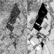
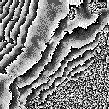
Figure 1. Left: denoising; middle: a degraded (blurred and noisy) image; right:
its restoration.
| Segmentation and classification |
Many applications call for the image domain to be split into pieces, each piece corresponding to some entity in the scene, for example, forest or urban area, and in many cases for these pieces to be assigned the appropriate label. These problems too are long-studied, but there is much progress to be made, in particular in the use of prior geometric information.
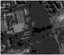
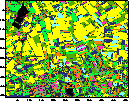
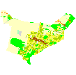
Figure 2. Left: a satellite image; right: its classification.
As the resolution of remote sensing imagery increases, so the full complexity of the scene comes to the fore. What was once a texture is now revealed to be an arrangement of individual houses for example, or a number of separate trees. Many new applications are created by the availability of this data, but efficient harvesting of the information requires new techniques.
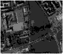
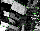
Figure 3. Left: road network extraction; right: tree extraction.
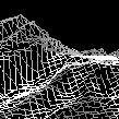
Earth observation and cartography is not solely concerned with 2D images. One important problem is the construction of 3D digital elevation models (DEMs) from high-resolution stereo images produced by satellites or aerial surveys. Synthetic aperture radar (SAR) imagery also carries elevation information, and allows the production of more accurate DEMs thanks to interferometry techniques, for example.
Figure 4. Left: DEM; right: interferometry.
| Information mining and database retrieval |
Every day, vast quantities of data are accumulated in remote sensing data repositories, and intelligent access to this data is becoming increasingly problematic. Recently, the problem of retrieval from large unstructured remote sensing image databases has begun to be studied within the project.
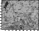
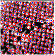
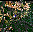
Figure 5. Image registration for the evaluation of retrieval systems. Left: mosaicked aerial image data; right: registered ground truth classification.


 2011 Activity report