Research topic:
Remote sensing image segmentation-classification is one of the big challenges for researchers in image analysis. In my work, I am interested in a variational approach to shape modeling based on « higher-order active contour » (HOAC) models and phase field models for line network (roads, rivers, ...) extraction present in very high resolution remote sensing images.
Ph.D. thesis abstract:
The high resolution (HR) optical satellite images make it possible to obtain a quantity of information never attempt in the past. This information can be used with an aim of environment storage, but also for other objectives if one is able to effectively extract it from the data. Thanks to the many high resolution satellites currently in orbit, or to come, the search for algorithms able to extract such information became a priority for the space agencie in France, Europe and the rest of the world. The goal of this thesis is to develop methods to extract road and river networks present in such images and particularly identifying the area in the image containing such networks.
The networks present in HR images occupy a region of dimension 2 which show specific morphological characteristics (for example, they are made up of arms which meet with junctions), but which have topologies without constraints. In order to model such areas, it is necessary to develop sophisticated approaches incorporating many a priori knowledge relative to the morphology of the area. Higher Order Active contours (HOAC) are a solution to build such models. This new generation of active contours makes it possible to model various morphologies of areas via the inclusion of long range interactions between points located on the edge of an area. One model supporting the areas of the form of networks was used successfully to extract road networks from middle-resolution images. A recent reformulation of the HOAC as non-local phase fields gives several advantages which makes this new formulation the modeling which will be used in future research tasks.
Key words: Phase field, phase transition, higher order active contours, geometric prior, shape, line extraction, roads, rivers, high resolution satellite and aerial imagery.
Phase Diagram of a higher-order active contour model
Abstract: This work addresses the question of stability of HOAC models. HOAC models introduce sophisticated prior geometric knowledge to describe a general family of shapes. These models define a long-range interaction energy. This new generation of active contours is used to extract road networks and trees from remote sensing images by selecting good values for the HOAC model parameters.
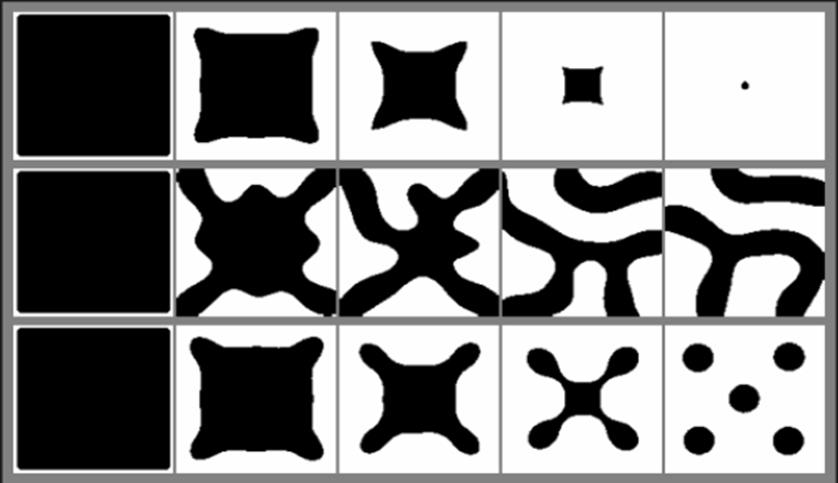
Figure: Geometric evolutions of a HOAC energy using Gradient descent algorithm for different parameter setting.
First, we start our study with the stability analysis of the « gas of circles » model for tree detection application. Our aim is to determine the model's phase diagram and hence obtain the range for the parameters of the HOAC model and the radius of the resulting stable circle. The second part of this work is to determine the phase diagram of « long bar » model, for road network extraction. The stability analysis for both configurations (bar and circle) is based on a Taylor series expansion of the energy up to second order. The first and second derivative of the energy allow us to constrain the HOAC model parameters.
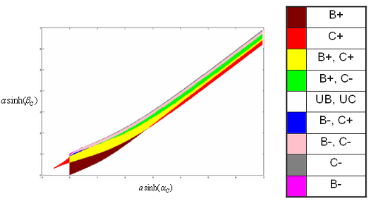
Figure: Phase diagram of a HOAC energy. The letters B, C and U refer to Bar, Circle and Unstable
respectively.
The symbols + and - refer
to positive and negative energies respectively.
The phase diagram leads to select parameter values for circlar and line structure modeling. We show here an application of line structure modeling: road network extraction from VHR remote sensing images.
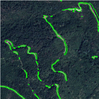
Figure: Road network extraction from a VHR remote sensing image.
Key words: Higher order active contours, geometric prior, shape, line extraction, tree detection, high resolution satellite and aerial imagery.
For more details about this work (.pdf in French) or the slides (.pdf in English).
Resolution dependence of adaptive wavelet packet coefficients for the classification of remote sensing images.
Abstract: In this work, I was interested in texture description using adaptive wavelet packet bases. Recent work showen that standard wavelet coefficient histograms can be modeled by a generalized Gaussian, this is not true for adaptive wavelet packet coefficients. In this case we observe three types of histogram: Gaussian, generalized Gaussian, and, in some subbands, we have multimodal histograms, which can be modeled by a constrained mixture of Gaussians. To estimate the model parameters, we adopt an adaptive probabilistic approach for each texture based on a Bayesian methodology.
Multimodal subbands can play an important role in discriminating textures of natural or remote sensing images. In remote sensing, images are formed by several sensors and each of them is characterized by a PSF (Point Spread Function). Thus, our goal is to study the resolution dependence of adaptive wavelet packet models for remote-sensing images.
Key words: Multiresolution analysis, adaptive wavelet packet, probabilistic approach, texture, MAP estimate, image segmentation, image indexing.