 Image Tilings
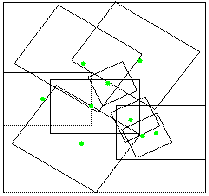
A problem in cartographySuppose we are given a set of images of different sizes which together cover a region and which may overlap, taken from an airplane or coming from a stellite for instance. The problem is to merge these pictures to form an image of the best possible quality, knowing that the information has
|
 |
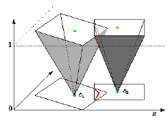 |
For our construction, it helps to think of the image in 3 dimensions:
|
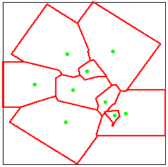
The best-quality mapThe best-quality map is then formed by the vertical projection of the lower envelope of the cones onto the plane, as if the cones were seen from the point at infinity towards the negative z coordinates.In general, some parts in an image may not be usable, for instance if they are covered by a cloud. One solution consists of projecting these parts onto the cones and to retriangulate. The best-quality map is then the vertical projection of the lower-envelope of the resulting collection of triangles. |
 |
Back to the welcome page of the PRISME Project